

How To Hike Mori Point (Pacifica) – Amazing Coastal Trail
Have you ever seen anyone drive a car off the cliff at Mori Point? Spoiler alert – it comes from a movie which I’ll mention in this article. Mori Point has such an incredible landscape with amazing coastal scenery and a network of trails to hike. It also has a unique history!
The Mori Point hike is a favourite among people in the Bay Area, and I want to share the magic with you. There are several ways to explore Mori Point, with 6 different trails with varying difficulties. We tried one of the more popular but difficult ones, so I’ll also be giving you some tips and insights on how it’s like, and ways you can stay safe.
In addition to the trail we hiked, I’ve also come up with a recommendation that will be easier yet still giving you the essential Mori Point experience. I trust AllTrails most of the time, but I would read the reviews more carefully for the “Mori Point Loop Trail” which is rated as the most popular.
I hope that got you excited to hike Mori Point let’s dive into this article where I’ll share a little bit about Mori Point and the various trails you can consider based on your fitness level and preference.
This article uses affiliate links where I make a small commission if you make a purchase through my links, at no additional cost to you. As an Amazon Associate I earn from qualifying purchases.
Where is Mori Point
Mori Point is located in Pacifica, along California’s famous Pacific Coast Highway. It is just south of San Francisco, about 15 miles (24 km) and around 20 minutes’ drive away. If you’re looking to do a day trip while you’re visiting San Francisco, this would be one of my top recommendations because of how easily you can get here.
What is Mori Point

Mori Point is a scenic promontory, which means an elevated land jutting out above the sea, and it spans 110 acres. It’s worth coming here because of the stunning views you’ll get to enjoy of the surrounding coastal landscape.
Did you know that Mori Point is part of the Golden Gate National Recreation Area? Not only does it have great views, it has diverse plant and wildlife and a network of hiking trails for outdoor lovers to explore this coastline. No wonder it’s one of the popular hikes in the Bay Area.
There are also benches for you to sit and look out towards the sea at Mori Point. Why not try to see if you can spot whales in the distance while you’re here?
What is the history of Mori Point
Mori Point was named after the Stefano Mori family who came and settled in the Pacific area in the 1870s. This area has an interesting history of being a hot spot for bootlegging, aside from being a resting place for travelers and settlers.
If you want to find out more, this is a really great reading to check out – it actually made me chuckle because of how vibrant this place was during the Mori Family’s era. For now, here’s a quick summary of the history of Mori Point:
- 1700s: Used by the Spanish as a limestone quarry to supply whitewash for the Presidio buildings in San Francisco.
- 1888: 19 acres of farmland purchased by an Italian immigrant, Stefano Mori. He built Mori Point Inn which was operated by his family until the 1940s.
- 1940s: Used for gravel and sand extractions during World War II, which destroyed the natural landscape.
- 2000: Mori Point was purchased and added to the Golden Gate National Parks for protection.
Does Mori Point have a beach

The nearest beaches to Mori Point are Rockaway Beach and Sharp Park Beach. Other beaches like Pacifica State Beach and Mavericks Beach are a short drive away.
Best time to hike Mori Point
As with most hikes in the coastal area, early morning or late afternoon near sunset is the best time. That’s because you won’t have to bear the heat of the mid-day sun, and you get softer (less harsh) lighting which is better for photography.
Here’s what you can expect when visiting Mori Point at various times in the year:

Spring: The best time of the year to hike Mori Point is in Spring, and you should definitely look out for the Superbloom. The weather is generally mild, making it an excellent time for a leisurely hike.
Summer: Summer offers warmer temperatures, and the days are longer, providing more time for exploration. However, the coastal climate is usually characterised by fog and low clouds which limits visibility.
Fall: At this time of the year, there are fewer crowds as the landscape starts to change towards the colder months. There are still days where you can enjoy warm weather with fewer days of fog compared to summer.
Winter: Winter brings cooler temperatures, and the weather can be unpredictable. While the scenery is still beautiful, be prepared for rain and chilly conditions. You can also tide pool nearby in Half Moon Bay.
When to see Superbloom in Mori Point
You can see Superbloom in Mori Point during the months of April to May, especially after a heavy bout of springtime rain. During this time, the area will be blanketed by colorful wildflowers. In fact, Mori Point might be the best place in California to see Superblooms!


Mori Point Wildflowers 2024
In Apr 2024, we took hike #1 and followed the Bootlegger’s Steps up to Mori Point to find a blanket of yellow wildflowers. I really like this route as it’s easy and the round trip walk takes only about 40 minutes.
Here are the flowers we saw:
- California Goldfields (blooms from March to May)
- Tidy Tips (blooms from March to July)
- California Poppies (blooms from March to May)
- California Checkerbloom (blooms from March to July)
- Ice Plant succulent blooms (blooms March to May)
Important note: Don’t touch or pick the wildflowers – leave no trace as much as you can.
Mori Point Hiking Trails

By the way, there was a famous old movie called Harold and Maude (1971) where they drove a car off the cliff at Mori Point! Of course, that was way before Mori Point was bought over and protected.
Here are a few trails you can check out in Mori Point, with varying levels of difficulty to suit your fitness level and preference.
1. Old Mori Trail

This trail is mostly flat, with a straight accessible path leading you to the base of the Bootleggers Steps. There’s a boardwalk along the way where you can enjoy the restored native plants, and try looking out for red-legged frogs and garter snakes.
You can also head up the Bootleggers Steps to check out the view from Mori Point, which extends into the a few other trails that we’ll be talking about soon.
- Distance: 1.1 miles (1.8 km) round trip
- Difficulty: Easy
- Elevation gain: 97 ft (30 m)
- Starting point: Mori Point Trail Head
- Parking: Near the end of Bradford Way, Mori Point, and Old Mori Trail Head (37.619216, -122.486523)
Our experience on the Old Mori Trail and Bootleggers Steps
The Old Mori Trail was a super easy walk, and the round trip only takes 40 minutes. We took this route as a quick detour to see the wildflower superblooom at Mori Point in mid-Apr.
The parking lot at Mori Point Trailhead is small, so most people (including us) parked along the roadside. We found a spot quickly on a Sunday afternoon, so not too troublesome there.
The Old Mori Road is mostly flat as you walk beside a residential area, before going onto the boardwalk. There were some small pools of water due to previous days’ rain, but not enough for us to care about whether our shoes could handle it.
The base of the Bootleggers Steps starts with small steps, and it didnt feel scary to walk up and down. In fact, the view of the coast and Pacifica Pier is really good from the steps.
Overall, I recommend the Old Mori Trail (hike #1) for a quick visit to Mori Point.
2. Mori Point Ridge Peak Loop Trail

Following the Old Mori Trail at first, you’ll climb up the bootleggers steps to Mori Point, and then turning east to hike up the peak overlooking Pacifica. Eventually, the trail leads you back towards your starting point.
- Distance: 1.4 miles (2.3 km)
- Difficulty: Moderate
- Elevation gain: 273 ft (83 m)
- Starting point: Mori Point Trail Head
- Parking: Near the end of Bradford Way, Mori Point, and Old Mori Trail Head (37.619216, -122.486523)
3. Mori Point Loop Trail (AllTrails version)

I recommend the AllTrails’ Mori Point Loop Trail for anyone who is 1) visiting Mori Point for the first time, 2) doesn’t mind a challenge, and 3) is not too nervous about heights. We chose this route (clockwise direction) and it was breathtaking!
- Distance: 2.6 miles (4.2 km)
- Difficulty: Moderate – hard
- Elevation gain: 400 ft (122 m)
- Starting point: Pacifica Quarry Running Trail
- Parking: Small road just off Highway 1 at (37.614110,-122.488110)
Our experience on the AllTrails Mori Point Loop Trail
At first you’ll be walking along a bike path, through some unmarked paths in a restored marshland. It’s pretty nice here with the pampas dotting the area, with hills and ridges in the background. Make sure to save the trail map and follow it closely because there are some not-so-obvious turns you’ll be making.

Soon enough, you’ll be led up a steep and narrow path. It was a little bit sketchy but we made it. I saw some reviews on AllTrails saying that it’s not a kid-friendly path and I somewhat agree.

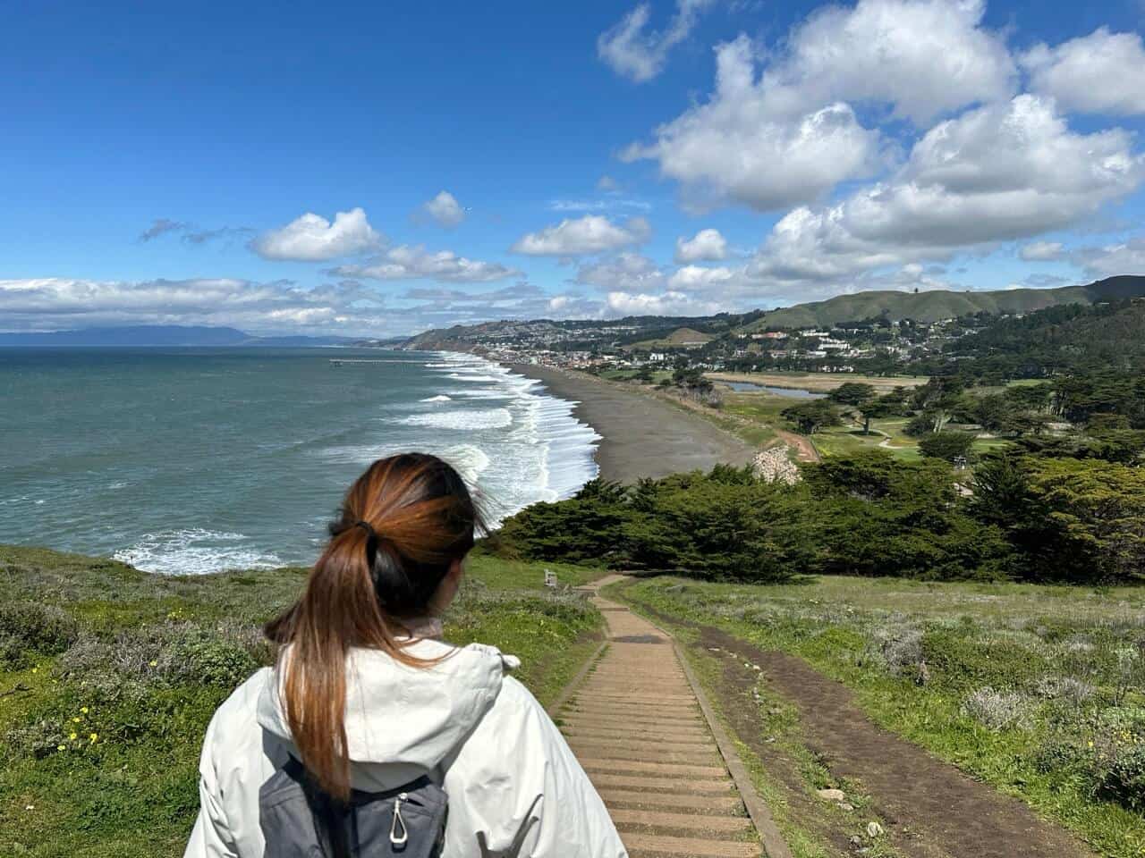
The views were incredible though! You’ll be able to see Rockaway Beach after the initial ascend up the bluff. Later on there were one or two more parts of the trail that might involve a bit of rock scrambling for the average hiker.

Nothing too crazy though, just make a mental note not to descend in this direction. We also saw some graffiti-ed concrete structures, which I think might have been related to the limestone kilns in years past.

From here, the trail takes you further along the coast towards Mori Headlands Trail and Mori Point. The rest of it is mostly a pleasant walk atop the bluffs until we reached Mori Point. After that, we turned onto the Coastal Trail which connected to Lishumsha Trail, and then Upper Mori Trail.
What we would have done differently
The last part of the trail that takes you back to the starting point involves a steep uphill climb up and down the ridge via Timigtag Trail. It can get slippery and muddy on a wet day, and I don’t really recommend this when you can just take the roadside trail instead. Besides, there’s not much of a view along this uphill route.
4. Mori Point and Bluff Trail via Bootleggers Steps (Recommended)

For a more relaxing but still quintessential Mori Point experience, I recommend hiking via Old Mori Trail and Bootleggers Steps up to Mori Headlands Trail and Mori Point. Afterwards, continue towards the Bluff Trail to enjoy the breathtaking views of the coastal cliffs. In fact, it seems like most people access Mori Point directly via the Bootleggers Steps instead of the longer AllTrails Mori Point Loop Trail.

When you’re ready to head back, you can leave the Mori Headlands Trail at the 6-way function via Coastal Trail and Lishumsha Trail which later joins back to Old Mori Road.
- Distance: 2 miles (3.2 km)
- Difficulty: Moderate
- Elevation gain: 236 ft (72 m)
- Starting point: Mori Point Trail Head
- Parking: Near the end of Bradford Way, Mori Point, and Old Mori Trail Head (37.619216, -122.486523)
5. Mori Point Trail (AllTrails version)

A great way to experience the beach together with Mori Point is to walk along Sharp Park Beach via the Promenade/Coastal Trail. This will connect you to the Bootleggers Steps as well, where you can access Mori Point and the adjacent Bluff Trail. The distance below includes a hike out to the Bluff Trail and back down along the beach to your starting point.
- Distance: 2.8 miles (4.5 km) round trip
- Difficulty: Moderate
- Elevation gain: 308 ft (94 m)
- Starting point: Parking area to the left of the Pacifica Municipal Pier
- Parking: At the end of Clarendon Road, Beach Road and Coastal Trail (37.629929, -122.493851)
Where to start Mori Point hike
For our recommended trail in option 4, or any hike that begins with Old Mori Trail, you would start from Mori Point Trail Head.
If you’re going on the Mori Point Loop Trail (AllTrails version), the starting point is at Pacifica Quarry Running Trail. However, I reckon you can also start from Mori Point Trail Head and walk along the road to get to Pacifica Quarry Running Trail.

How long does it take to hike to Mori Point
On average, it takes between 1-2 hours to hike to Mori Point via the various trails.
- If you are going on the Mori Point Loop Trail (Alltrails version), it will take around 2 hours.
- The other trails beginning from the Old Mori Trail will take on average 1 hour assuming you’re heading up the Bootleggers Steps to Mori Point as well.
- If you’re including Sharp Park Beach in your hike, that may take and additional 30 minutes for an out and back journey.
Why is it called Bootleggers Steps?
Before the current set of steps leading up the bluff was constructed, “rumrunners” used to trek up to the top to deliver shipments to the shops from the coast. It was considered dangerous at the time as the area was not developed like it is today.
I wondered about this question too before finding out about the history behind Mori Point. Isn’t that such a fun fact?
Where is the best place to park at Mori Point
These are 3 main places you can consider parking at to access Mori Point, with the following coordinates you can input into Google Maps directly.
- Best for trail options 1, 2, 4: Mori Point Trail Head (37.619216, -122.486523) – Most popular
- Best for trail option 3: Pacifica Quarry Running Trail (37.614110,-122.488110)
- Best for trail option 5: Sharp Park Beach (37.629929, -122.493851)
Things to do nearby
Pacifica comes up as one of the top places to go to in the Bay Area, and it’s easy to see why.

- Pacifica State Beach – why not have lunch at the most scenic Taco Bell?
- Grab coffee at Soul Grind Coffee Roaster
- Devil’s Bunker
- Pedro Point Headlands
- Mavericks Beach – watch surfers or check out the king tides during winter
- Half Moon Bay – explore downtown or check out the beaches
Where to stay
Unfortunately, the historic Mori Point Inn is no longer in operation as it got burned to the ground in the 1960s. Instead, consider these beachfront hotels/motels near Rockaway Beach.
If you’re staying in San Francisco instead, do refer to this guide where I share some thoughts on where to stay in San Francisco for safety. In that case, you may also need to rent a car, which I also have some tips for.
What to bring
Here are some things you should bring along to your Mori Point hike. You can also refer to what I normally use in my Travel Resources page.
- Rain jacket especially during winter when the weather is unpredictable.
- Shoes with good grip and support to tackle any rock scrambling or uphill walks.
- More than enough water and snacks for the entire hike, especially on a hot day.
- Warm layers like a fleece jacket for when the fog and wind makes it extra cold all of a sudden.
- A decent hiking backpack to fit all your layers, water, and snacks (maybe even a camera!).
- Trekking poles to help with any steep parts, or for help with going down the Bootleggers Steps.


