

12 Places You Need To Hike In The Bay Area Now (Peninsula and South Bay)
Looking for a fun hike in the San Francisco Bay Area? There are a ton of outdoor spaces here in the Peninsula and South Bay, and you don’t have to drive for hours to go hiking.
There is a great diversity of landscapes in the San Francisco Bay Area that you can explore through a hike. These hikes offer a mix of coastal walks, forest trails, panoramic vista points, and historic landmarks.
Whether you are looking for a relaxing walk during your Highway 1 road trip, or a challenge to work up a sweat, there’s a hike just for you. It’s also great for weekend mornings with family and friends. When you’re done hiking, you can just pop by a nearby cafe and have brunch to start the day.
I really love living in this part of Northern California! In this article I want to share more about the amazing hiking spots you should check out in the Peninsula and South Bay.
This article uses affiliate links where I make a small commission if you make a purchase through my links, at no additional cost to you. As an Amazon Associate I earn from qualifying purchases.
El Corte De Madera Creek Preserve (Redwood City)
This preserve is know for its lush forests (redwood, Douglas firs, chaparral) including the huge Methuselah Tree that is 1,860 years old. The Methuselah Tree does not require a hike and is such an amazing thing to see in the Bay Area.
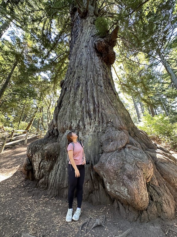
If you come for a hike here during a foggy morning, you will feel like the forest and mossy surroundings start to look more dramatic and other-worldly.

1. Tafoni, Resolution and Fir Trail
The El Corte De Madera Creek Preserve is also known for its unique sandstone formations called Tafoni. These are sandstone rock structures that have been eroded over time to have honeycomb-like patterns.

There’s also a sad incident that look place here in the 1950s, when a plane named “Resolution” crashed into this part of the Santa Cruz Mountains.
The Resolution Trail is a tribute to this tragic event where you may even see some plane debris along the trail. If you do, please refrain from touching or moving them.
I love that this trail also has a scenic vista point with a picnic table that overlooks the Pacific Ocean. You can find it along the Fir trail, just further ahead from the memorial rock dedicated to the Resolution.
I also wrote another article about this trail in more detail, do check it out if you’re planning to hike in El Corte de Madera Creek Preserve.

Distance: 4.9 miles (7.9 km)
Duration: 2.5 to 3 hours
Elevation gain: 820 ft (250 m)
Things to look out for: Ocean view from vista point, Resolution plane debris, redwood trees
Half Moon Bay
This coastal stretch along Highway 1 has many beaches and trails for a relaxing weekend getaway. Aside from the stunning coastline and tide pooling, it also has a charming small-town atmosphere.
Half Moon Bay State Beach has different four beaches – Francis (main hub with a campsite), Venice, Dunes and Roosevelt.
It is also home to the famous Ritz-Carlton Half Moon Bay, a luxurious hotel for a romantic weekend that sits atop the coastal bluff.

2. California Coastal Trail to Ritz Carlton
Starting from the California Coastal Trail parking lot, this trail leads you north towards Ritz-Carlton Half Moon Bay.
You will walk on the top of the coastal cliff above Manhattan Beach, though you can also make a detour to visit the beach via a set of stairs.
Passing by the hotel’s golf course, you will get to the Ocean Terrace at the Ritz-Carlton. If you want to indulge, you can also enjoy a drink here with some bar seafood and snacks. There are outdoor communal fire pits that feel so romantic especially in the evenings.

I highly recommend coming here during sunset for an easy walk. Just remember to come early to get parking and bring a sweater along!

Distance: 1 mile (1.6 km)
Duration: 20 minutes
Elevation gain: 49 ft (15 m)
Things to look out for: Ocean Terrace at Ritz-Carlton Half Moon Bay, coastal bluffs at sunset, beach access
3. J V Fitzgerald Marine Reserve Bluff Trail
J V Fitzgerald Marine Reserve is an excellent spot for both a serene walk along the Bluff Trail as well as for tide pooling at low tide.
The Bluff Trail takes you from the main entrance and parking area to a viewpoint overlooking the coast. Then, you’ll walk through the serene Eucalyptus grove that provides shade from the sun while you admire the beach from the bluff.
Once you get to Cypress Avenue, you can access Moss Beach via Seal Cove Trail. The rocky shores are home to a multitude of marine life, including anemone, mussels, shrimps and crabs. Bring along a flash light if you’re visiting close to sunset as you’ll need to walk back to your car.
One of the best times to tide pool is during low tide during winter’s king tide days. I also recommend staying for sunset as it gets really magical here.

Distance: 1.2 mile (1.9 km) round trip
Duration: 30 minutes round trip
Elevation gain: 46 ft (14 m)
Things to look out for: Marine life (anemone, mussels, shrimps, crabs) in tide pools, beach access, and sunset views
Golden Gate National Recreation Area (San Francisco)
There is a long coast stretch on the western side of San Francisco near the Golden Gate Bridge. The Golden Gate National Recreation Area had a military history, and you can still see some of the forts here.
You can experience a diverse range of landscapes here as well, like rugged coastlines, beaches, cliffs, forests and views of the iconic Golden Gate Bridge.

4. Lands End to Golden Gate Bridge
The hike begins in Lands End on the northwest corner of San Francisco. You will notice that the vibe is totally different here compared to downtown San Francisco.
You can visit the Lands End Lookout visitor center and also see the ruins of the Sutro Baths which used to be the world’s largest indoor swimming pool complex.

Continue on past the beautiful Sea Cliff neighbourhood and onto the Batteries to Bluffs section of the route. Throughout the trail, you will see amazing views of the Pacific Ocean and Marin Headlands as you hike towards the Golden Gate Bridge.

My favorite part was when we got to walk along the sand and take pictures at Baker Beach. It’s also fun because you can make detours to the breach if you feel like it. The trail ends at the touristy side of the Golden Gate Bridge where you can call an Uber to pick you up.

Distance: 4.5 miles (7.2 km)
Duration: 2 to 3 hours
Elevation gain: 656 ft (200 m)
Things to look out for: Sutro Baths, oceanside bungalows at Sea Cliff, Baker Beach, Golden Gate Bridge
5. Andy Goldsworthy’s Wood Line
The Presidio is located at the northern tip of the San Francisco Peninsula that also used to be a former military post. Andy Goldsworthy’s Wood Line is actually an art installation that was created in 2010, using eucalyptus branches and trunks from the Presidio.
A walk down this meandering path through the peaceful eucalyptus forest will no doubt be a great addition to a trip to San Francisco. There are other attractions nearby where you can continue to on, including Palace of Fine Arts.

Distance: 0.2 mile (320 m)
Duration: 5 minutes
Elevation gain: flat
Things to look out for: Photo opportunities and curved wood-lined path
Windy Hill Open Space Preserve (Portola Valley)
Windy Hill is a popular spot for hiking and trail running. It is known for its windswept grassy hills and is a great place to hike for panoramic views of Stanford University and the Bay Area.
Windy Hill Summit is the highest point in the preserve, and is perfect for watching the sunrise or sunset. It can also be reached by driving up to Skyline Boulevard.

6. Windy Hill Loop
Start your hike near the Willowbrook parking lot and hike in an anti-clockwise direction from Spring Ridge Trail onwards. The first half of the hike is mostly unshaded but takes you up the hill quickly. Remember to look back to admire the view of the bay as you gain elevation.
There are lookouts at the Windy Hill summit with picnic benches for you to rest and enjoy the view. Follow the Anniversary Trail and continue slightly on the Lost Trail until you reach a fork. As a fun fact, this part of the hike along the top is part of the Bay Area Ridge Trail.
Finally, turn onto the Hamms Gulch Trail, a cool and shaded forest route that leads you downhill back to where you came from.
The only bathrooms along this trail are the portable toilets at the parking lot near the Anniversary Trail Picnic Tables. There are also no drinking water points here so do bring more than enough water.

Distance: 6.4 miles (10.3 km)
Duration: 3.5 to 4 hours
Elevation gain: 1,400 ft (427 m)
Things to look out for: View of Stanford University, forest oak and redwoods
Stanford Dish (Palo Alto)
If you’re visiting Stanford University, why not pay a visit to the Stanford Radio Telescope, also known as the Stanford Dish. It is a prominent landmark on campus and is popular with students and professionals nearby, and one of the best things to do around Palo Alto.
The Stanford Dish is accessible to the public only during specific hours which changes each month. As a guide, it would be somewhat close to sunrise and sunset times.
7. Stanford Dish Loop Trail
The Stanford Dish Loop Trail allows you to see the Stanford campus and the surrounding Santa Clara County. It is highly accessible as a paved road, so you can even come here with strollers too.
The trailhead begins at the Stanford Gate, and you can follow the trail markers from L1 through L21. You can go either direction, and you will find the Stanford Dish at L14.
There are portable toilets at the entrance, but since it’s a relatively short trail it’s best to use the toilet elsewhere.

Distance: 3.7 miles (6 km)
Duration: 1.5 to 2 hours
Elevation gain: 534 ft (160 m)
Things to look out for: Stanford Dish and the view of Stanford University
Rancho San Antonio County Park (Los Altos)
Rancho San Antonio is one of the most popular parks to hike in the South Bay of the San Francisco Bay Area. There are a variety of trails for you to explore and is easily reached just off the highway. A hike here will bring you through diverse landscapes including meadows, forests and views of the the Bay Area .
The parking lots fill up really quickly even though there are 6 lots in total. We were there in summer and had to wait about 20 minutes to get parking even though we arrived at 8am. That just tells me that people here are early hikers!
There is also a farm called Deer Hollow Farm that is open to the public free of charge (closed on Mondays and mornings only on Wednesdays). It has been here since 1853 and the original caretakers’ home has been preserved. You can visit the animals including sheep, goats, ducks and pigs.

8. Coyote, Upper High Meadow, and Stephen E Abbors Loop
Head to the Coyote Trail to start your hike which passes by the Deer Hollow Farm. After that, continue on the High Meadow Trail that leads you to one of the vista points.
There will be a couple of forks, so make sure that you are following the Upper High Meadow Trail to the highest point of this loop where you’ll find another vista point. Once you’ve rested enough from the earlier uphill hiking, take the Stephen E Abbors Trail that winds down back towards the Coyote Trail.

We enjoyed the varied landscapes that emerged as we hiked through the winding trails. At some point we even saw some deer!
The nearest parking lot is at lot 1, but it is a carpool only site. That means you will need at least 3 people to be able to park there. I recommend parking at lot 6 as it is quite big and also has restrooms.

Distance: 8.4 miles (13.5 km)
Duration: 4 hours
Elevation gain: 1,686 ft (514 m)
Things to look out for: Deer Hollow Farm, vista points overlooking the bay
Pacifica
Pacifica is set on a rugged coastal landscape that offers plenty of hiking options. Located just 15 miles away from San Francisco near Highway 1, it’s easy to see why this place is a local favorite.

9. Mori Point Loop Trail
This is one of the popular trails in Mori Point for those who are looking for a short challenge. Starting from the parking lot, you’ll first walk past a small section of memorial gardens. The trail then opens up to wild pampas surrounding you as you begin the hike on the dirt trail.
It’s important to have a map with you as the trails are not very well marked, so GPS helps you to stay on the intended trail. Going counterclockwise, we come to our first relatively steep incline on a narrow part of the ridge. I recommend wearing shoes with good grip when you’re hiking this Mori Point Loop Trail as some parts of the hike involve a bit of scrambling and walking up steep ridge slopes.

Mori Point was slightly more crowded compared to the trail, so it’s likely that most people took alternative routes to get there. For example, you could go on the Coastal Trail and then take the Bootleggers Steps up to Mori Point. There are a few benches for you to sit and watch the ocean here, so take your time to enjoy the view.
The way back to the car was quite straightforward and much flatter, other than the final uphill walk to cross the ridge near the end. Overall, the hike is doable and it gives you an amazing view of the ocean.
The parking area can be found at the Google Maps location of “Pacifica Quarry Running Trail”. However, there aren’t many spaces here so do arrive early during weekends. You can read more about our experience with the Mori Point hike here.

Distance: 2.6 miles (4.2 km)
Duration: 2 hours
Elevation gain: 400 ft (122 m)
Things to look out for: Amazing ocean and coastal views along the trail
10. Montara Mountain North Peak Loop
If you are a fan of ocean, city views, and elevation gain, try the Montara Mountain North Peak Loop. It starts from the parking area near Devils’ Bunker and Gray Whale Cove State Beach, and leads you uphill through a steep trail. As you go higher up, more of the coastline comes into view, making the effort worth it.
Once you pass the initial steep section, the trail takes on a more gradual incline, as it winds around the mountain revealing views of Pacifica. On clear days, you’ll be able to see the Golden Gate Bridge, and even nearby peaks like Mount Diablo.

You don’t really need to go the whole way up to the official peak as the view doesn’t get that much better near the top. On your way back down the trial, the AllTrails route takes you somewhat off-trail. If you prefer not to, follow the longer route to loop back around via the gentler Gray Whale Cove Trail.
The view coming back will be slightly different as it shows more of Half Moon Bay’s coastline including Pillar Point. Overall, it’s a fun hike with panoramic views all around.
The best time to hike here is around winter to spring, as the weather is still mild and you’ll have the chance to see the wildflowers blooming on the rolling hills.
Distance: 7.4 miles (11.9 km)
Duration: 4 to 4.5 hours
Elevation gain: 1,778 ft (542 m)
Things to look out for: Changing views of Pacifica, San Francisco, Mount Diablo and Half Moon Bay.
Purisima Creek Redwoods Open Space Preserve (Woodside)
Purisima Creek Redwoods Open Space Preserve is located on the western slopes of the Santa Cruz Mountains facing Half Moon Bay. It is one of the most popular places to hike for many in the Bay Area because it’s almost halfway between San Francisco and San Jose.

11. Whittermore Gulch to Harkins Ridge Loop Trail
The most popular hike in Purisima Creek is the Whittermore Gulch to Harkins Ridge Loop Trail. Here, you’ll first hike down into the gulch along the running creek, and then loop back uphill back to the parking lot. It can be a little challenging because of the incline, but the trails are broad with clear signs.
Enjoy sweeping ocean vistas beyond Half Moon Bay as you start the hike. I was actually blown away by this view as many of the forest hikes in the mid-peninsula have very slim windows to see the ocean. Try to see if you can see Pillar Point and the waves at Mavericks Beach. In the rainy seasons you’ll also get to see many banana slugs amidst the flourishing moss-covered forests.
Read more of my experience and how you can navigate the Whittemore Gulch to Harkins Ridge Loop Trail in this article.

Duration: 6.5 miles (10.5 km)
Duration: 4 hours
Elevation gain: 1,745 ft (530 m)
Things to look out for: Vista views of Half Moon Bay and the ocean, banana slugs, hiking along a creek
Mission Peak Regional Preserve
Mission Peak Regional Preserve is located in Fremont in the East Bay and is one of the most popular hikes in the Bay Area. It’s known for its relentless climb and iconic summit pole (that gets decorated during the holidays).
This hike attracts locals looking for a physical challenge and sweeping views across the Bay. On clear days, you can even see Mount Diablo, Mount Tamalpais, and as far as the Sierra Nevada mountains.

12. Mission Peak hike
The most popular hike in here is the Mission Peak Loop from the Stanford Avenue Staging Area. Although the hike is short in distance, it can feel challenging due to the continuous elevation gain and limited shade.
That said, the trails are wide, well-maintained, and clearly signed, making it accessible for first-time hikers who are prepared to take breaks. As you gain elevation, enjoy expanding views of the Bay Area and surrounding mountain ranges.
Near the summit, the terrain becomes rockier and windier, so it’s a good idea to layer up before taking photos at the peak. You may also encounter grazing cows along the lower sections of the trail, which adds to the unique character of this hike.
Read more of my experience and tips for tackling the Mission Peak hike in this article.

Duration: 6 miles (9.7 km)
Duration: 4-4.5 hours
Elevation gain: 2,152 ft (656 m)
Things to look out for: Mission Peak pole, panoramic Bay Area views, grazing cows, rocky summit terrain
What to bring for your hiking trip
To make the most of your adventure, it’s essential to come prepared. Here’s a checklist to ensure you have everything you need.
Hiking essentials and comfort items
- Hiking boots or shoes: Comfortable and supportive footwear is a must so you’ll have the best experience. Waterproof boots can be useful for muddy trails.
- Hiking day pack: It should have enough space to store snacks, water, and any extra clothing. Here are some affordable hiking backpacks below $100 to consider.
- Water: Stay hydrated, especially during warmer months. Water reservoirs with up to 3-litre capacity are useful for longer hikes. In general, bring at least 0.5 litres for every hour of hiking.
- Map and navigation: Having offline trail maps adds an extra layer of security. Offline Google Maps also helps.
- Snacks: Pack energy-boosting snacks to keep you fueled throughout the hike. These could be energy bars, nuts, or some sweets.
- Sun hoody: This UPF 50+ sun hoody is very breathable, comfortable, and blocks her 98% of UV from reaching your skin.
- Sunscreen and cap: Protect yourself from the sun, especially during the open sections of the trail.
- Layered clothing: For example, bring a fleece sweater and wear a sweat-wicking base layer. Rain jackets can also act as a windbreaker.
- Camera
- Phone tripod: If you’re hiking alone, having a phone tripod is great for filming shots of yourself.
- Trekking poles: Provide extra stability on uneven terrain and downhill sections.
More of my travel guides to help you plan your classic California experience
Lassen Volcanic | Lake Tahoe | Yosemite | Point Reyes | San Francisco Day Trips | Half Moon Bay | Pescadero | Big Sur | Santa Cruz | Monterey | Carmel-by-the-Sea | Catalina Island | Death Valley | 10-day California Road Trip | Rental car tips | Bay Area Must-Visit Places
Not sure where to start? I have some ideas for your California trip!
Best stops along California’s coast | Must-go for outdoor lovers | Best winter camping | Bucket-list backpacking trips | Best SF Bay Area hikes | Best California Glamping | Best beach towns


