
Rafferty Creek, Vogelsang, Lyell Canyon Loop (3 Day Yosemite Backpacking): What You Need To Know
This might be one of the best 3 days you will ever spend in California’s backcountry. The Rafferty Creek, Vogelsang, Lyell Canyon loop in Yosemite is a classic backpacking route with landscapes that amaze you each day.
This was our first backpacking trip so we weren’t looking to do anything too ambitious. After researching and planning for a long time, we decided on the Rafferty Creek, Vogelsang, Lyell Canyon Loop.
Although it was going to involve high altitude (up to 10,600 feet), the daily distance was kept to around 7 miles, without crazy elevation gains. We’ve gone on many hikes in the SF Bay Area, so we were eager to take on the challenge.
If you’re planning to hike this loop as well, you’re in for a treat! There are so many alpine lakes here, and early in the season you might even see stunning snow-capped peaks. Dispersed camping along this trail is also incredibly scenic, and I would recommend this backpacking trip in a heartbeat.
In this article, I’ll share some essential information about this route, and what it’s like out on the trail.
This article uses affiliate links where I make a small commission if you make a purchase through my links, at no additional cost to you. As an Amazon Associate I earn from qualifying purchases.
About the Rafferty Creek, Vogelsang, Lyell Canyon Loop
Duration: 3 days
Total distance: 20 miles (32.2 km)
Total elevation gain: 2,473 feet (754 m)
Difficulty: Hard
Nearest parking spot: Dog Lake Parking
Trailhead name: Rafferty Creek -> Vogelsang (Lyell Canyon Trailhead)
Where we camped: Boothe Lake, Lyell Canyon junction
Browse permit availability below
⬇️ Watch our vlog to come along the journey with us ⬇️

Map and route types
This is the AllTrails map I created that marks out our daily route. You can also download it as a GPX file and upload it to your navigation device for future use.
We also referred to this version that contains notes at various waypoints about things you’ll see and places to camp. The main difference is that we included a visit to Boothe Lake, and we went in a counter-clockwise direction for a gentler elevation gain.
People also commonly refer to this route as the Ireland and Evelyn Lake Trail, or even the Rafferty Creek/Lyell Canyon Loop.
It’s also popular to take trips along Rafferty Creek (red route) or Lyell Canyon (blue route) only, but this time we’ll be going up in elevation to complete a loop through Vogelsang (includes the green route).

Things you need to know
To help you plan your backpacking trip with confidence, here are some things you need to know about the Rafferty Creek, Vogelsang, Lyell Canyon Loop.
In addition, refer to my Yosemite packing list for a quick guide on what to bring along.
Getting wilderness permits for Rafferty Creek->Vogelsang
You will need to reserve wilderness permits to backpack in Yosemite. There are limited permits issued per day, and in this case we will be going for the Rafferty Creek -> Vogelsang trailhead.
In the reservation, you will be asked to input the camp areas you intend to stay at. You can indicate Boothe Lake and Upper Lyell Canyon, but you don’t necessarily need to stick to it. I spoke to a Wilderness Center ranger who reassured me that it doesn’t matter that much. You just need to book for the correct trailhead and number of nights.
The permits are available up to 24 weeks (6 months) before your trip, so that means you should start looking to book your summer backpacking dates in January. If you are looking for some last minute dates, you can also book them up to 3 days in advance.
As a last resort, walk up permits are also available on a first-come, first-served basis at various Wilderness Centers in Yosemite.
You can find out more information about the booking process here.

Best time to go
The best time to go on this backpacking adventure is between August to September. That’s because you get to avoid the terror of swarming mosquitoes in June and July. However, the creeks would be much drier closer to fall, and you’ll need to plan your water supply more carefully.
From October onwards, the weather starts to get a little more unpredictable as the backpacking season comes to a close.
In addition, the Rafferty Creek and Lyell Canyon trails to Vogelsang are accessed via Tioga Pass which are open between May and November each year. However, the exact dates are never guaranteed because it depends on how long it takes for the snow to be cleared from the roads.
How much it costs
You will need to pay the usual entrance fee for Yosemite National Park which costs $35 per vehicle. If you have the annual pass (America The Beautiful), it will be free for you.
Wilderness permits cost $10 per person, and it is non-refundable even if Tioga Pass does not open before your trip date.
Safety tips
Bears: You’ll be in the same territory as black bears in Yosemite, so you are required to store your food in bear canisters. Do note that bear spray is not allowed, but there are ways you can stay safe.
Mosquitoes: The worst mosquito season here is during June and July when the snow melt creates stagnant pools of water. If you’re backpacking during this time, treat your clothes with permethrin, use bug spray, or bring a head net. Avoid wearing dark colors because mosquitoes are attracted to it – don’t make the same mistake as me.
Navigation: Make sure you have your offline trail maps downloaded (such as AllTrails), portable phone chargers, and maybe even a waterproof paper map for backup. We used our Garmin inReach Mini 2 for navigation most of the time since the route was straightforward.
Portable chargers: Between AllTrails, photos, and navigation, our phones drained faster than expected. A lightweight power bank was essential.
Altitude sickness: Above 9,000 feet is where some people start to feel the effects of altitude sickness. Since this route goes up to 10,000 feet on the first day, consider spending a day to acclimatise at the Tuolumne Meadows backpackers camp. Staying well hydrated is another way to avoid the negative side effects.
Creek crossings: If you’re going in early summer, be prepared for lots of water in the creeks and multiple unbridged crossings. For early summer crossings like these, quick-drying trail runners and collapsible trekking poles made a huge difference for stability.

Trail and road conditions
These are a few things we looked out for leading up to the trip:
If you’re looking to continue your Yosemite trip exploring other parts of the park, here’s another trip idea you can consider.
Our experience on the Rafferty Creek, Vogelsang, Lyell Canyon Loop
Trip dates: mid June 2024
This was our very first backpacking trip, and thankfully Tioga Pass opened just in time for our permit dates. Most people advised us to keep our mileage at around 7 miles as beginners, so this backpacking route was just the right amount.
Although it would have been good to stay at a campground along Tioga Pass the night before, they were all unavailable when we were there. Hence, we stayed at Hodgson Meadow Campground instead which was just 1 hour 20 minutes drive away from the trailhead.
First-time backpacker? Read this first
This was our very first backpacking trip, and these were the few items that mattered way more than we expected on this route:
🦟 Mosquito defense at Vogelsang
👟 Quick-drying trail runners for water crossings
💧 Fast flowing water filter and bladder system

Day 1 noon – Start the trail at Rafferty Creek towards Vogelsang
Distance: 6.85 miles (11 km)
Elevation gain: 1,433 feet (437 m)
You’ll need to pick up your wilderness permit before starting your trail. Fortunately, there’s one near the trailhead at Tuolumne Meadows Wilderness Center. You can rent a bear canister for $5/week and ask about trail conditions there.
Make sure not to leave any scented or food products in your car, and use the bear lockers provided in the parking lot. We decided to take the loop in a counter-clockwise direction, so we set off onto Rafferty Creek trail.
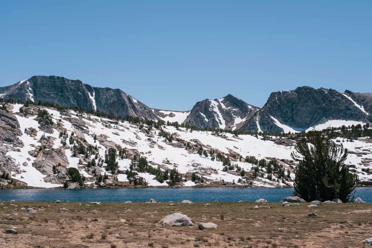
It wasn’t long before we started to see the peaks in the distance, and we knew it was going to be amazing. The hike up along Rafferty Creek towards Vogelsang is a gradual uphill, and we started to feel short of breath as we crossed 9,000 feet.
Along the way, there were several unbridged creek crossings since it was still early summer and water levels were high. Around the half way point, look out for Rafferty Falls across the creek.

Eventually, you’ll get to Tuolumne Pass which reveals Vogelsang peak in all its glory. The green grass and unmelted snow pack with the mountainous backdrop was really scenic and made us forget our fatigue for a moment.
At this point we had just reached 10,000 feet elevation. The mosquitoes were also starting to become relentless. This was when we decided we really should’ve treated our clothes with Permethrin.
If you’re going in early summer like we did, permethrin-treated clothing or a head net is not optional. This is what we wish we had from day one.


Day 1 evening – Camp at Boothe Lake
Eventually, we reached the fork with signs indicating that Boothe Lake was just 0.6 miles away. We took a longer time than expected due to the headache and lethargy from the elevation gain.
The last mile or so felt really long, but we made it to the north shore of Boothe Lake. It was clearly an established campsite and thankfully there wasn’t anyone else there.

Since we got the space all to ourselves, we quickly set up our tents, made dinner, and enjoyed the last bit of evening sun in this gorgeous corner of Yosemite.
There were fish in the water, but somehow the lake became super calm after the sun set.

Day 2 morning – Hike up to Vogelsang High Sierra Camp and beyond
Distance: 7.36 miles (11.85 km)
Elevation gain: 889 feet (271 m)
We enjoyed a relatively calm morning as a light breeze kept the mosquitoes away. After having breakfast and coffee, we packed up camp and went back up towards Tuolumne Pass.
With our renewed energy after some sleep, we climbed uphill and safely made our way through the remnant snowpack on the trail. As we went up, we could see Boothe Lake towards our right while Vogelsang Peak started to appear larger.

It wasn’t long before we arrived at the Vogelsang High Sierra Camp which sits at above 10,000 feet. At this time they were still under construction so there were no working toilets there. We walked around just to see what the camps would be like, and whether we would pay about $180 per night to stay there.

Just outside the perimeter of the High Sierra camp is the Vogelsang Backpackers’ Camp which had bear boxes provided. It would be convenient to stay here if we had the energy to make it all the way up on Day 1, but then again the mosquitoes here were crazy too.

Nonetheless, it’s a very scenic spot to camp if you’re visiting outside of mosquito season, but it might get cold because of the higher elevation. You can even see Fletcher Lake in the distance.
Day 2 afternoon – Hike past Fletcher Lake and Evelyn Lake
We continued our journey past Fletcher Lake which sits beneath Vogelsang Peak. There was a waterfall there too, called Fletcher Falls, which could be heard as walked past the lake.

After another uphill section with more snowpack, we finally came to a viewpoint that overlooked Evelyn Lake and another smaller lake beside it.

This spot definitely makes for an ideal scenic campsite since it’s not too close to the lake (and mosquitoes). We decided to make a stop here for lunch so that we could enjoy the view a little longer.

The walk past Evelyn Lake was mostly flat and quite easy, aside from the one time we had to switch to sandals to cross a stream rushing from the lake. As you can tell, there’s no shortage of water sources here.
For the rest of the day, we would see another unnamed lake which almost marks the end of all the uphill parts.
Day 2 evening – Descend into Lyell Canyon to camp
The highest point of this stretch connecting Rafferty Creek to Vogelsang and Lyell Canyon was about 10,600 feet. We really enjoyed all the alpine lakes and mountain scenery here, and admired the view once more before descending below the tree line.

If you have time, you can consider going on a 3-mile detour to see Ireland Lake. Personally, we felt like the lakes we saw have been amazing so we gave Ireland Lake a miss.
The walk down into Lyell Canyon was very relaxing and the terrain was easy. It was like a walk in the park after all the uphill portions earlier. The mosquitoes also seemed to be less aggressive, and our dull headaches disappeared as we went below 9,000 feet.

Finally, we reached the trail junction that told us that we’ve made it to the John Muir Trail. We could hear the rushing sound of the Lyell Fork, which meant it’s time to pick a campsite!
It was clear that this is a super popular spot for people to camp, and there were already 2 to 3 groups before us so we ventured further downstream. Thankfully, there was just the perfect spot in a little clearing with enough trees to give us privacy from other campers.

We had instant noodles which was super gratifying after a long day of hiking, and fell asleep to the sound of the river.
Day 3 morning – Follow the John Muir Trail out of Lyell Canyon
Distance: 5.8 miles (9.35 km)
Elevation gain: 150 feet (46 m)
We took our time to wake up on the last day since we didn’t have a lot of distance remaining. As first time backpackers, our bodies were not used to the physical exertion and we could feel all of our muscle aches in the morning. For some reason I felt it more in my hip flexors and shoulders.
We started to see groups of hikers pass by our campsite as the morning went on, so we took it as a sign to get going.

The first part of the trail back along Lyell Canyon was almost right next to the river, followed by meadows and rocky paths that are further away. We waited until we got close to the river again to take an early lunch break and sun bathe on the rocks.

Overall, Day 3 was fairly easy and the only thing I would complain about would be my pack that I was so ready to put down. As we hiked the rest of the trail, we talked about all of our favorite moments and views.
Eventually, we got to the same wooden bridges we crossed at the start of our journey, signalling the end of the Rafferty Creek, Vogelsang and Lyell Canyon Loop.
We did it – our first backpacking trip!

What we’d do differently next time
Looking back on our first backpacking trip, there are a few small things we’d change that would have made the experience noticeably more comfortable, especially on a high-altitude route like this.
- Take mosquito prep more seriously
Early summer mosquitoes around Vogelsang were relentless, especially in the evenings. Treating our clothes with permethrin ahead of time would’ve made a bigger difference than just relying on bug spray.
→ What we’d bring next time: a permethrin spray for clothing - Add an acclimatisation night near Tuolumne Meadows
Jumping straight into hiking above 10,000 feet on Day 1 was tough. Spending a night near Tuolumne Meadows before starting the trail would’ve helped our bodies adjust and reduced the headaches and fatigue.
→ What would’ve helped: electrolytes for altitude and hydration - Bring lighter backpacking gear overall
By Day 3, the weight of our packs was very noticeable. Lighter gear would’ve made the long, flat miles through Lyell Canyon much more enjoyable, especially as beginner backpackers.
→ What we’d upgrade first: a lighter backpacking pack
Conclusion: The Rafferty Creek, Vogelsang, Lyell Canyon Loop is worth it
Looking back, it wasn’t the easiest route for a beginner backpacker but it’s amazing how much beauty there is in this entire backpacking trail. Once you start hiking Rafferty Creek towards Vogelsang, those mountain views just keep getting better as you climb higher.
Just when you think Day 1 was amazing, Day 2 comes at you with the most amazing lakes you’ve seen in a while – Fletcher and Evelyn Lakes.
Even as you’re taking a relaxing downhill hike back to close out the loop, Lyell Canyon offers glimpses of the surrounding peaks and calm meadows beside the rushing river.
With so many places where you can camp with scenic views, it’s easy to see why the wilderness permits are in high demand.
If you’ve gone hiking before and are moderately fit, I highly recommend backpacking the Rafferty Creek, Vogelsang, and Lyell Canyon loop! To check out more multi-day backpacking trips worth doing in California, check out this post.


Good morning. I tried to get to your post on AllTrails so we could replicate your trip. For some reason, I keep getting an error message. Would you be able to share it directly through email? My very first solo trip was to Booth Lake, which is where I decided to stay after exploring the Vogelsang backpackers camp. The Packers camp was just too crowded for my likes. I did up an back to Booth Lake in one night, two days. I have always wanted to return and do the entire loop.
Cheers!
Susan